

When a new planet swims into his ken;
Or like stout Cortez when with eagle eyes
He star'd at the Pacific--and all his men
Look'd at each other with a wild surmise--
Silent, upon a peak in Darien.
There are places in here that are so large and well done that one can't help feeling a little like Cortez, and nowhere in Second Life is this more true than when looking out across the Rumsey maps. I went as a lark, with no idea what to expect and my fellow Artsparkian and map enthusiast Leonard Hawker joined me.
From the link above, you'll TP into the welcome area on Rumsey maps 3 - there are 4 sims here, for some reason the explorer pack offered on the welcome signs wouldn't materialize for me, so I was disoriented from the start, but that really added to the experience. The welcome sign also suggests you change the 'draw distance' on your graphics settings from low (and on my horse-drawn computer, it's set very low) to the maximum. I obeyed and immediately there was a lot of freezing, followed by a faux Scottish brogue inside the hard drive gasping "Captain, she can't take any more". But at the same time I became aware of the grandeur of my surroundings. A map of the world lay at my feet but as you can see it filled the horizon - that's me sitting in the middle foreground. There are pins you can personalize and place in your place of residence (interesting: beyond the obvious red zones and the unclaimed pins, there seem to be a lot of Residents living on the high seas...)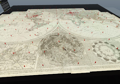
When I finally found a level of graphics compatible with breathing, we went and checked out the building which is a museum, gallery and library all at the same time, and found a wonderful array of old topographical pictures, many of US cities, but also such exotica as Buenos Aires, Tokyo and The Moon, laid out with simple elegance, and all free to take home. For no particular reason I got one of Minneapolis, along with a nice animated globe! Upstairs there's a video showing the RL home of the Rumsey Collection, too. The build took about three months to complete, it's by Nathan Babc
 ock of centric, and was finished in May of this year. I asked Nathan for a photo for this article, expecting one of his avatar, he sent this lovely shot instead. He was working on behalf of David Rumsey a millionaire cartophile philanthropist whose huge map collection graces his home in San Francisco. For Mr. Rumsey (in SL Map Darwin), putting maps in Second Life is only one of several ways he shares and protects these historical works of art: more than 11,000 are to be found on his website in collaboration with Luna Imaging who incidentally also work with my all-time favourite site, Catena. While I got carried away looking at all the little pictures, Leonard donned his jetpack and was gone *everso slightly rolls eyes*.
Incoming IM: 'I'm on a giant map,' he said. He sent some photos that seemed to take forever to rez.
'I know,’ said I. ‘A map of the world with pins in it. I saw it before.'
'No, this is New York. The clarity of detail is amazing. I’m about 350 meters above it, but you can see the people standing on the balcony of the American Museum.'
'TP!'
I'm not really sure how, but moments later we were standing on Manhattan Island as it appeared in maps in 1836. I felt like Daryl Hannah as we wandered down the East River towards the Brooklyn Bridge, with the Empire State Building in the background.
Maps have been with us since ancient times, of course. Traces may be seen on the great monuments of the Babylonian and Egyptian civilizations. In Homer's masterpiece, the heroes of ancient Greece spend an epic decade looking for the way in to Troy and a further ten years trying to get home without consulting passers-by or maps. Indeed it was not until 1896 when, during a secret conference held in Vienna between Nietzsche, Bertrand Russell, Mark Twain and Antonio Gramsci, the still revolutionary concept of men asking for directions was developed. The resulting highly controversial pamphlet: Zu Fahrtrichtungsanzeigeren von Menschen (colloquially known as entschuldigen Sie bitte) was suppressed during the Great War for security reasons. Unlike people, animals do not use conventional maps, but they also have strategies for communicating location and direction: bees use complex 'dances' to tell the hive where pollen may be found, and it is well known that bears leave Geostatic Personal Substances at regular intervals in the woods.
At Rumsey maps you'll also find the famous Cassini Globes, made in Rome in 1792. The terrestrial globe shows the earth mapped as it seemed in the age of Captain Cook; in a delightful flight of Italian symmetry, Cassini produced a second, matching ball this time representing the stars, an important navigation tool at the time and one that Leonard assured me can still be used on occasion. The originals are about 50 cm high, but here they are gigantic - so big, you can go inside... it's just one of the many ways that virtual worlds offer more than the real world, for once inside, with mouselook, you have a 360 degree view that defies description ... say no more, except that in the Library life-size - or do I mean avatar-size? - copies are freely available for you to bring home. This is getting a little bewildering.  There's plenty more to see but probably the most memorable aspect of Rumsey maps is the Yosemite Valley survey map, which covers all four sims at ground level. There's a high up, high-tech central platform that allows you to enjoy the panorama in various modes. If you're a map lover, you may be here for hours, so bring sandwiches. It's actually 2 versions of the same survey, one flat on the ground, the other made of sculpties crafted to mimic the contours of the terrain, so you see and even can fly through the canyons and up over the crests. In the distance, this wonderful picture of the Grand Canyon adds a sense of even greater grandeur to one of the most breathtaking places in Second Life.
*****
Poi mi sentì come un osservatore dei cieli,
Quando una nuova pianeta nuota nella sua coscenza
O come Cortez forte quando con occhi di aquila
Fissò ’l Pacifico – e tutti i suoi uomini,
Si guardarono con congettura selvatica –
Silenzioso, su una vetta in Darien.
John Keats, Guardando per la prima volta all'Omero tradotto da Chapman
Ci sono posti qui che sono talmente grande, talmente ben fatti che ti fanno sentire come Cortez, sulla vetta di Darien, incantato dall'immenso. E forse, specialmente se costruisci, un po' costernato dalla bravura altrui. Io sono andata a fare una piccola gita a Rumsey maps e con me c'era Leonard Hawker, anche lui del gruppo ArtsParks e appassionato di carte geografiche.
Il link sopra riportato ti porterà direttamente al centro di accoglienza su Rumsey 3, una dei quattro sim che formano questa straordinaria land. Prova a cliccare sulle cartelle, offrono un exploration pack - per me non hanno funzionato, ma forse tu avrai più fortuna. Davanti a te troverai un bel museo o meglio una galleria-pinacoteca piena di stampe topografiche raffiguranti vari luoghi in America e altrove - ho trovato tra le immagini di un'America elegante novecentesca un bellissimo quadro di Tokio e anche vari disegni della luna e le costellazioni, tutte opere del sette- otto- e novecento. Viene consigliato di cambiare il livello della 'draw distance' (Edit - Graphics) cioè mettendolo al massimo in modo di poter vedere gli oggetti molto distanti, sul mio povero PC questo cambiamento ebbe un brutto effetto, lasciandomi un po' spaesata - sensazione appropriata in un luogo dedicato alle mappe. Vale la pena cambiare livelli grafici, si tratta d'una panorama veramente grande in ogni senso della parola. Mi sono trovata davanti una carta geografica piena di spille rosse (foto sopra nella parte inglese). Volendo, puoi aggiungere i tuoi dati ad una delle spille a disposizione e posizionarla dove abiti tu ... ma devo dire che, a giudicare dalle spille che ho visto, un numero cospicuo di residenti abitano nel Atlantico...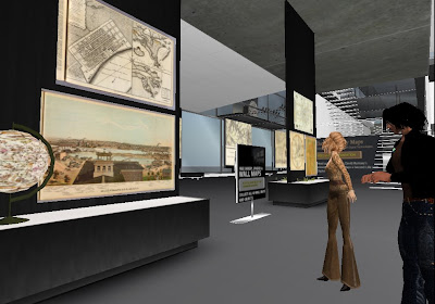
Per la costruzione, realizzata da Nathan Babcock di centric.com, ci sono voluti tre mesi circa. Ho chiesto a Nathan una foto, intendevo dell'avatar invece mi ha mandato il bel ritratto real che troverai sopra nella parte inglese. La mostra è stata inaugurata a maggio di quest'anno proprio da David Rumsey (in SL Map Darwin) in persona. Filantropo, cartofilo, newyorkese ma residente a San Francisco, il sig. Rumsey ha una vasta collezione di mappe, cartine e stampe topografiche. Se vai al secondo piano della galleria troverai una presentazione video della sua raffinatissima casa californiana, colma di tesori cartografici. Introdurre in Second Life le sue mappe è solo uno dei modi il sig. Rumsey protegge e diffonde le preziosissime - e spesso fragili - carte della sua collezione, cominciata negli anni ottanta. Da circa dieci anni lavora con varie ditte software (tra le quali lunaimaging.com, collaboratori sul mio sito preferito Catena). Sul sito ufficiale di Rumsey maps, troverai oltre 11,000 di queste vere e proprie opere d'arte. Mentre io guardavo i bei quadri nel museo, Leonard è uscito col jet pack a dare un'occhiata in giro.
'Bello qui!' disse. 'Cammini sulla mappa gigante! Però è abbastanza grande da vedere le persone sulla griglia del balcone nell'immagine dell'american museum!'
'Ma sei sulla mappa del mondo? Con le spille rosse? L'ho vista.' 'No è una mappa di New York circa 1800.' TP!' 'Ok, ma sono in aria...a 315 mt altezza. Comincia a volare prima per alta quota.' 
'Non fa sentire come se fossimo pulci?'
Aveva ragione. Poco dopo ci trovammo per terra, camminavamo sul fiume East a New York direzione Brooklyn. Da pulci eravamo diventati giganti, mi sentivo una donna in 'crescendo'. C'era in 3D il ponte di Brooklyn, l' Empire State Building e altre case sulla mappa che non ho saputo identificare. Qui c'è molto da vedere, dal punto di vista storico-culturale. Le carte geografiche esistono dai tempi antichissimi, basta pensare ai capolavori di Omero nei quali gli uomini greci prima non riescono a trovare la via per entrare nella città di Troia, e poi sprecono un altro decennio cercando la strada di casa. Si dice che nel 1896, durante una reunione segretissimo tenuta a Vienna tra Nietzsche, Bertrand Russell, Mark Twain, e Antonio Gramsci, è nato il concetto tutt'oggi rivoluzionario dell'uomo che si ferma a chiedere indicazioni. L'opuscolo risultante Zu Fahrtrichtungsanzeigeren von Menschen (conosciuto anche come entschuldigen Sie bitte) fu messo al bando durante la Grande Guerra per motivi di sicurezza...
Qui a Rumsey troverai anche le famose sfere di Cassini (Roma, c. 1792) opera d'arte e documento storico allo stesso tempo. Una rappresenta la terra come sembrò all'epoca dei grandi navigatori brittanici quale il capitano Cook, e l'altra, gemella, ci illustra le costellazioni utilissime per la navigazione. In real, sono alte circa 50 cm ma qui in Second Life sono enormi (costruite usando megaprim) e si possono entrare e godere la loro bellezza da dentro in uno spettacolo possibile solo in un mondo virtuale. In un bel gioco di prospettiva, nella galleria troverai anche copie di grandezza 'naturale' - a misura d'avatar - da portare a casa.
Forse l'aspetto più notevole di Rumsey maps è la carta topografica di rilevamento della vallata del Yosemite databile alla fine del '800. Incorniciata da una stupenda veduta del Grand Canyon, questa magnifica pianta di uno dei più spettacolari parchi statunitensi ricopre l'intero pavimento dei quattro sims di Rumsey. Al centro in alto troverai una piattaforma che consente di vederla in vari modi. La mappa è stato realizzata anche con sculpties che seguono le linee isometriche, le curve naturali di questo paesaggio formoso. E quando ti stanchi della storia e degli aspetti technici che questo luogo ti invita ad ammirare, puoi spiccare il volo, come un'aquila, e volare per i canyon e gli altopiani del Far West...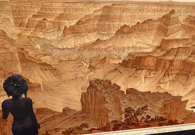
No comments:
Post a Comment